
Loisto Mariner
In-app purchases

10K+
Downloads

Everyone
info


About this app
Loisto Mariner is the best companion to boater: tools for navigation, weather forecast and identifying of other boats
with Automatic Identification System (AIS) are always in your pocket!
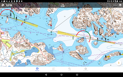
Navigate easily with the Finnish nautical map or hike with precise topographical maps.
Loisto Mariner takes you where ever you want to get:
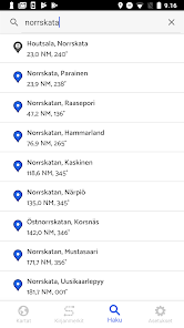
• Find your destination with the advanced location search provided by the National Land Survey of Finland.
• Enjoy boating also on the lake area – the nautical chart covers Finland's inland waters like Lake Saimaa.
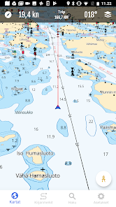
• Navigate on Finland's marine area with familiar Finnish nautical charts.
• Hike with precise topographical maps.
• Plan your routes on land and in the sea.
• Check the weather forecast and find a place to rest from a guest harbor.
🗺 The clearest and highest quality maps of Finland on the same app.
The nautical charts and topographical maps are precise and in vector format. The nautical charts of the app are based on
the material of the Finnish Transport Infrastructure Agency.
Navigational line information is now also available e.g. from the following lakes: Kivijärvi (Luumäki, Lemi), Karelia
Pyhäjärvi (Kitee, Parikkala), Pyhäjärvi (Säkylä), Lokka and Porttipahta lakes, Kiantajärvi, Rautavesi-Kulovesi,
Ontojärvi, Kyrösjärvi, Keurusselkä, Pyhäjärvi (Iitti), Kimola canal.
The general nautical charts cover Åland, Archipelago, Gulf of Finland and Lake Saimaa. The topographical map is based on
the most accurate material from National Land Survey of Finland.
The combined view of the topographical map and nautical charts is even more detailed.
You can use the maps also offline. Save the offline maps to your device and plan routes and navigate successfully, where
ever you may roam.
🔍 The advanced search covers thousands of locations.
The index is based on the location database of the National Land Survey of Finland.
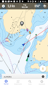
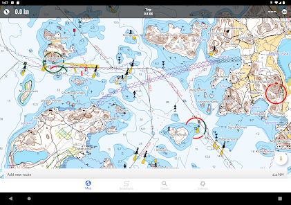
🚢 The AIS data helps you to identify other boats.
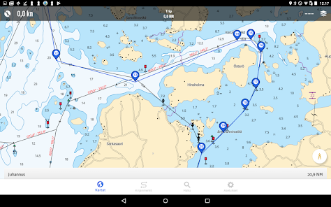
🚤 You can also easily see your current location on the map. See the maps from the bird's-eye view (3D) and you can
easily get a quick glance of your route.
With the compass tool, you can measure distances and directions while navigating. Your track will be visualized on the
map as a clearly distinguishable line. You can decide the length of the direction vector from the settings.
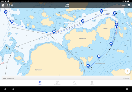
🌐 Plan routes and save your favorite locations.
Measure the distances between places, the length of the route and duration of the trip. You can easily save your
favorite spots on the map.
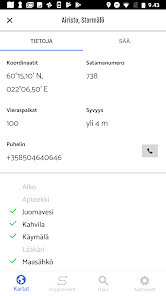
⚓ Stop by at the guest harbor.
The app helps you to find the guest harbor along the Finnish coastline and on the lakeside. The services of the harbors
are listed. The information is provided by Suomen Vierassatamat Ltd.
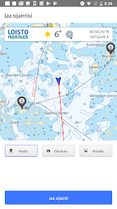
👋📸Share your location and the spectacular view!
You can share your location straight from the app to your favorite social media services. Choose one of your own images
or a screenshot from the map to be shared.
The weather forecast and coordinates of your location will be shown on the image. You can start sharing by tapping your
location icon on the map.
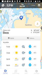
🌤 Reliable weather forecast always at hand.
The local weather forecast is provided by the Finnish Meteorological Institute. Up-to-date weather forecast requires
that your device is online.
💶 The yearly subscription fee is only 34,99 €. Start now navigating with Loisto Mariner!
The subscription period is 12 months from the purchase. The price includes all map updates and app updates. The
subscription on Google Play renews automatically unless you unsubscribe. You can mange your subscriptions by tapping
Menu and Subscriptions.
Tips for using the app (in Finnish): https://www.loistonavigointi.fi/loisto-mariner
Contact us or give feedback (in Finnish): https://www.loistonavigointi.fi/tuki-loisto-mariner
with Automatic Identification System (AIS) are always in your pocket!
Navigate easily with the Finnish nautical map or hike with precise topographical maps.
Loisto Mariner takes you where ever you want to get:
• Find your destination with the advanced location search provided by the National Land Survey of Finland.
• Enjoy boating also on the lake area – the nautical chart covers Finland's inland waters like Lake Saimaa.
• Navigate on Finland's marine area with familiar Finnish nautical charts.
• Hike with precise topographical maps.
• Plan your routes on land and in the sea.
• Check the weather forecast and find a place to rest from a guest harbor.
🗺 The clearest and highest quality maps of Finland on the same app.
The nautical charts and topographical maps are precise and in vector format. The nautical charts of the app are based on
the material of the Finnish Transport Infrastructure Agency.
Navigational line information is now also available e.g. from the following lakes: Kivijärvi (Luumäki, Lemi), Karelia
Pyhäjärvi (Kitee, Parikkala), Pyhäjärvi (Säkylä), Lokka and Porttipahta lakes, Kiantajärvi, Rautavesi-Kulovesi,
Ontojärvi, Kyrösjärvi, Keurusselkä, Pyhäjärvi (Iitti), Kimola canal.
The general nautical charts cover Åland, Archipelago, Gulf of Finland and Lake Saimaa. The topographical map is based on
the most accurate material from National Land Survey of Finland.
The combined view of the topographical map and nautical charts is even more detailed.
You can use the maps also offline. Save the offline maps to your device and plan routes and navigate successfully, where
ever you may roam.
🔍 The advanced search covers thousands of locations.
The index is based on the location database of the National Land Survey of Finland.
🚢 The AIS data helps you to identify other boats.
🚤 You can also easily see your current location on the map. See the maps from the bird's-eye view (3D) and you can
easily get a quick glance of your route.
With the compass tool, you can measure distances and directions while navigating. Your track will be visualized on the
map as a clearly distinguishable line. You can decide the length of the direction vector from the settings.
🌐 Plan routes and save your favorite locations.
Measure the distances between places, the length of the route and duration of the trip. You can easily save your
favorite spots on the map.
⚓ Stop by at the guest harbor.
The app helps you to find the guest harbor along the Finnish coastline and on the lakeside. The services of the harbors
are listed. The information is provided by Suomen Vierassatamat Ltd.
👋📸Share your location and the spectacular view!
You can share your location straight from the app to your favorite social media services. Choose one of your own images
or a screenshot from the map to be shared.
The weather forecast and coordinates of your location will be shown on the image. You can start sharing by tapping your
location icon on the map.
🌤 Reliable weather forecast always at hand.
The local weather forecast is provided by the Finnish Meteorological Institute. Up-to-date weather forecast requires
that your device is online.
💶 The yearly subscription fee is only 34,99 €. Start now navigating with Loisto Mariner!
The subscription period is 12 months from the purchase. The price includes all map updates and app updates. The
subscription on Google Play renews automatically unless you unsubscribe. You can mange your subscriptions by tapping
Menu and Subscriptions.
Tips for using the app (in Finnish): https://www.loistonavigointi.fi/loisto-mariner
Contact us or give feedback (in Finnish): https://www.loistonavigointi.fi/tuki-loisto-mariner
Updated on
Safety starts with understanding how developers collect and share your data. Data privacy and security practices may vary based on your use, region, and age. The developer provided this information and may update it over time.


What's new
New additions include the introductions of 501 destinations across the Gulf of Finland, Archipelago Sea and Åland Islands that are sure to pique the interest of recreational boaters. We also present 250 different fishing spots. Fishing spots for catching specific species of fish (pike, zander, perch, sea trout) are presented separately.
Nautical charts updated. Some bugs fixed.
Nautical charts updated. Some bugs fixed.


